
In a recent post over on Games from Folktales, Timothy commented on the concept of “Robinsonades” in terms of their story potential as a starting point for an Ars Magica Saga. Alluding to Shakespeare’s The Tempest as a potential source of inspiration, he broadly defines the concept in his first paragraph:
A Robinsonade is a type of story that takes its name from Robinson Crusoe. In the structure of the story a person from a technologically superior area is stranded in an area where they have limited societal support.
Read “magically adept” for “technologically superior” by invoking Clarke’s 3rd Law and he argues that starting a covenant from a shipwrecked group of magi and their surviving grogs is a potential Robinsonade beginning to a Saga. Let’s not get into the whys and hows of a group of magi travelling by ship and managing to get shipwrecked – that’s a whole different post or two – and take a moment to concentrate on the where, at least in terms of the Mediterranean, potentially linking into my Mythic Genoa concepts.

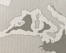
The above image is a photograph from a very useful book about Mediterranean History (The Corrupting Sea, Peregrine Horden and Nicholas Purcell, Peregrine 2000) that discusses the Meditteranean as a maritime continent or “extended archipelago” of ports and settlements along the coasts linked by a common culture. The map demonstrates those areas “out of sight of land”, the “deeps” of the ocean beyond the horizon which in this instance equates to the line of demarcation between where an individual on a ship at sea can still see land features including mountains and where the observer sees only an unbroken circle of water.
I’d like to explore these so-called featureless “deeps” later, but in his original post Timothy suggests that Sagas set on islands out of sight of a passing ship may make a good example of a Robinsonade. Let’s use then this map as a starting point for discussion.
Note: the image above presumably details what those on board a ship can see – unless an observer is standing on a high peak, their horizon at any coastal point is limited to mere 3 miles. An observer on the deck of a ship can similarly only see human sized objects at sea level 3 miles away, which according to this calculator extends for those in the crow’s nest or the top of the mast of most contemporary ships to about 10 miles at most in clear weather during daylight. This is only the top of the landmark however, the rest of the landmass is hidden behind the horizon. So it’s entirely possible to miss another ship or a beacon fire on the beach unless the smoke rises as a column or you have a lookout positioned up the mast. Also one ship may be able to see another’s mast from miles off while remaining undetected by the other crew at deck level or be completely hidden from castaways gazing out from the where they have waded into the waves…
Height above sea level, for both the observer AND the object is the key.
- sea level: 3 miles
- 30 feet: 7 miles
- 50 feet: 9 miles
If the top of the object and the observer are elevated, then the distance increases.
Historically, particularly in ancient times when oared galleys were the primary means of maritime transport, but also in medieval times of sail, most ships sailed within sight of the coast – within a few miles along the plains and further out to sea for coasts rocky headlands or mountainous coasts. To venture beyond this horizon was a concept that generated significant dread and had associated superstitions. Ships did sometimes cross the wider expanses with the aid of astrological navigation (itself a great topic) but much more rarely, so the borders on the map potentially represent the furthermost limit a ship would readily sail.
Although there’s no scale to the overall map (and technically the line varies by a few miles depending on the height of the observer if they’re at the top of the mast of the ship), it’s interesting to me for several reasons, but in response to Timothy’s post, let’s briefly deal with whether this map helps with the hypothesis that there are islands out of sight of passing ships traversing the common coastal routes of the Mediterranean and leave out those few intrepid ships and crews that cross the wider open expanses for now.
He mentions the Scilly Isles, the Channel Isles and the Hebrides, which are all part of more northern Tribunals, and does not mention the Aegean islands possibly because of the busy sea traffic in the Theban Tribunal. So let’s deal with the two Mediterranean suggestions: the islands off Sicily (Aeolian, Ustica, Aegadian, Pelagian) and the smaller islands between Spain and the Balearics.
Example #1: the Balearic Islands?
Let’s deal with the Balearics area first.
The initial map indicates that the Balearics, given their mountainous nature, are readily seen by ships sailing eastwards from the port of Valencia and the small islets off the coasts of the three main islands are well within the 10 mile diameter of a passing ship (blue circles on the map below) if not the 3 mile radius of being seen from the coast. So it’s really a question of whether the smaller island of Formentera (highest point 390 feet) south of Ibiza and the islets of the Cabrera Archipelago (highest point 560 feet) south of Majorca are easily visible.
Both lie within 10 miles of their nearby major islands, so their landward coasts are readily visible from a ship sailing within sight of the main coast and their peaks are easily seen from even further out (24 miles and 29 miles respectively, green circles on the map).
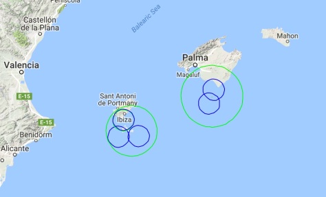
It’s unclear whether ships passed to the north or south of the Balearics (Edit: checking another reference, they probably did pass to the south due to the prevailing winds and currents of the western Mediterranean), but assuming they did round the southern coastline, Formontera with it’s overall flatter relief to the west and elevation to the east would be passed frequently. On the other hand, the rocky seaward side of Cabrera might be relatively hidden in the shadow of its highest central elevation from most passing ships hugging the Majorcan coastline to the north and therefore might be a potential Robinsonade style covenant location.

To be continued…
